Source: National Weather Service / NWS
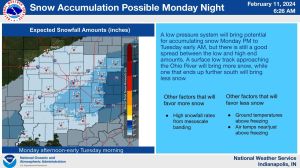
INDIANAPOLIS — Snowfall could make its way back into the weather again on Monday as forecasters are calling for rain to begin in the evening.
Temperatures are expected to dip below freezing overnight which could allow for some snow to mix in with the precipitation, impacting the southern and central parts of Indiana.
While accumulation would be minimal, the National Weather Service Indianapolis warns that as pressure builds within the storm system there is the potential for the snow to fall in intense bursts, impacting travel from the Muncie area down through Bloomington.
Precipitation is expected to wrap up around midnight, potentially lingering a bit longer in the southern half of the state. Indiana’s recent above average temperatures should keep the roads warm enough that hazardous conditions are not expected after precipitation has concluded.
Speaking of Indiana’s above average weather, last Friday saw a record high tied in Indianapolis as the temperature reached 66 degrees. That has only happened twice before in the city’s history on February 9th, 1943, and 1894. Another record was broken on that same day as the low for the 9th was only 54 degrees. Not only was that above the 30-degree average for that time of year, but it broke the previous highest low of 48 degrees set back in 1876.
The post Snow Could Impact Southern and Central Indiana Monday Evening appeared first on WIBC 93.1 FM.
Snow Could Impact Southern and Central Indiana Monday Evening was originally published on wibc.com