NWS: 6 to 12 Inches of Snow Possible Across Indiana
Source: NWS Indianapolis
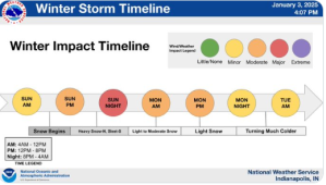
STATEWIDE–Some places in Indiana could get anywhere between 6 to 12 inches of snow between Sunday and Monday.
In a Friday afternoon press briefing, Mike Ryan with the National Weather Service in Indianapolis said the first round of snow is expected to start moving in Sunday morning and last through the overnight period.
“We’ll get a little breather and we’ll get another round of snow that will be heavier at times on Monday with some wind gusts that could cause some problems,” said Ryan.
Ryan said the widespread travel impacts are the big story.
“We do think snowfall amounts will be higher further south. We’re likely to see more sleet than freezing rain in those far southern Indiana counties. I’m talking areas like Knox, Vincennes, and Seymour,” said Ryan.
Ryan is most concerned about the I-70 corridor and areas surrounding it.
“That I-70 corridor and a little south of I-74 and on south to areas like Bloomington and Columbus. That’s where we’re confident the most in 6 and maybe as much to 12 inches of snow,” said Ryan.
What complicates this is that there is warmer air moving through the state.
“Warmer air that’s between 3 and 4,000 feet of loft could be a little bit stronger. It could cut into our snowfall totals. That means we could get more sleet versus snow,” said Ryan.
Ryan says there are still some things to sort out.
“The goal now going forward into Saturday is to lessen the low end and high end ranges to give you a higher range of confidence by lessening the snowfall range,” said Ryan.
NWS: 6 to 12 Inches of Snow Possible Across Indiana was originally published on wibc.com